About 75% of global industrial fishing and 25% of other vessel activity is not publicly tracked, asserts the new publication, Satellite mapping reveals extensive industrial activity at sea, issued in Nature with lead authors from Global Fishing Watch – a non-governmental organization that seeks to advance ocean governance through increased transparency of human activity at sea. The findings suggest that these vessels may be at higher risk of participating in illegal fishing activities, like fishing in marine protected areas, or contributing to forced labor or potential human rights abuses.
This also means that our understanding of “who” is fishing “where”, “how” and “in what conditions” the fishing activity occurs, can be limited. As a result, possible negative consequences for coastal communities, marine ecosystems and the global economy are almost impossible to measure.

Over 740 million people depend on the ocean for their livelihoods, nutrition, or both. That creates immense pressure on the ocean, combined with a wide range of harmful human activities that affect its state. Moreover, about a third of fish stocks are fished beyond biologically sustainable levels (threatening the reproduction of fish populations), and an estimated 30–50% of critical marine habitats have been lost owing to human industrialization.
What does public vessel tracking information mean for fisheries transparency?
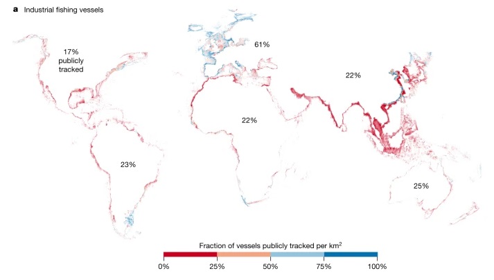
According to Nature, some of the largest cases of illegal fishing, together with human rights and labor abuses occurring at sea have been committed on vessels that were not using –or required to use- tracking devices. The study revealed that out of the approximately 63,000 vessels detected by GFW between 2017 and 2021, close to a half of them were industrial fishing vessels. Less than 25% of all industrial fishing vessels were publicly tracked, as presented in the following map (adapted from the publication).
When governments do not require the use of tracking devices for fishing vessels or do not make this information public, their vessels cannot be publicly tracked at the level required to effectively manage fishing activities at sea. For example, this research found fishing vessels not publicly tracked inside protected areas, including Galapagos Marine Reserve (~5 vessels/ week) and Great Barrier Reef Marine Park (~20 vessels/week).
What needs to be done?
The Coalition for Fisheries Transparency (CFT) is a global initiative that brings together civil society organizations to promote transparency in the global seafood sector. The coalition’s work is based on the 10 policy principles included under the Global Charter for Fisheries Transparency. One of them – principle five – requires governments to mandate the use of vessel tracking devices and make vessel position data publicly available. Sharing vessel tracking data can help reduce the likelihood of labor rights violations, measure the real impact of fishing activity to effectively manage fish stocks, and detect potential illegal fishing activity within marine protected areas. In 2023, CFT organized a regional workshop in Southeast Asia to learn more about members’ concerns around fisheries transparency, current efforts in the region, and opportunities for possible future collaboration with local organizations. Surprisingly, none of the countries in the Asia region currently makes vessel position data from vessel monitoring system (VMS) publicly available, and while data from Automatic Information System (AIS) is public, most countries do not require the use of AIS for all commercial fishing vessels.
Given the pervasive lack of transparency at sea, CFT calls on governments around the world to make vessel tracking systems a requirement, and its data publicly available to effectively monitor vessel activity at sea.